topImageName
Introduction
www.standingstones.org is a resource site for people who want to study Archaeoastronomy for Stone Circles, Standing Stones, Stone Rows and Henges.
www.StandingStones.Org providers a viewer to display the historic rising and setting points of the Sun and Moon - Viewer Tour and Viewer
Most of the source data for the site is sourced from the Megalithic Portal and would like to thank the Megalithic Portal for use of this data.
Viewer

Locations
Background
Archaeoastronomy (also spelled archeoastronomy) is the study of how people in the past have understood the phenomena in the sky, how they used these phenomena and what role the sky played in their cultures.
www.StandingStones.Org has a viewer to display the historic rising and setting points of the Sun and Moon - Viewer
The viewer has data accumulated from around 4000 sites across the UK and Ireland and many others from the rest of Europe including many Stone Circles, Standing Stones, Stone Rows and Henges.
The viewer images are based largerly on the SRTM (Shuttle Radar Topography Mission) data.
LIDAR data is used for all sites within England, Wales, Ireland and Norway with missing areas filled with SRTM data. The SRTM data is also augmented with the Ordinace Survey (OS) based 50m map data.
For UK Latitudes above 60 degrees (Shetland is mainly north of this) then OS data only is used.
For Scandinavia data for locations north of 60 degrees is from the VIEWFINDER PANORAMAS site and I would like to thank Jonathan de Ferranti for use of
this data
The SRTM data is easier to process and generally produces cleaner results than the OS data although the SRTM data sometimes can vary from actual maximum heights by around 20m due to an average being taken across a tile
(For instance, the SRTM tile for the summit of Snowdon is 20m below the top).
The OS data is composed of 10M contour lines so provides better accuracy on steep slopes while the SRTM data is probably more useful on less steep terrain and hence both are used in conjunction.
Spot heights where shown are from the OS data.
More details on most of the sites can be found at The Megalithic Portal.
Another useful reference site for many sites is The Modern Antiquarian.
The Northern Antiquarian site is a full of stories and legends about sites and is well worth a visit
Studies of the Stones Rows of Britain The Stones Rows of Great Britain.
Other reference sites include Canmore which is the online catalogue to Scotland’s archaeology, buildings, industrial and maritime heritage,
Coflein which provides a similar reference for Wales and Heritage Gateway for England
Megalithomania.com includes all sorts of historic and prehistoric sites across Ireland, including Neolithic, Bronze Age, Early Christian and Medieval monuments which is thankfully now resurrected from the internet archive.
Megalithomania.com.
Lunar sites Scotland. It is interesting to compare the site in the Thom's long solstitial alignments article with the same sites in the StandingStones Viewer (Ballochroy and Kintraw)
mega-what.com provides accurate surveys the Whole Horizon around some sites - useful comparison site
Sample Images
The following are example images taken from a small group of Standing Stones in Anglesey (Druid Farm, SH416751, 53.24921, -4.375564) and shows how the location could have been used to observe the sun and moon at different positions.
The Winter Solstice rising of the sun over Snowdon

Major Lunar Standstill (-E-I) rising over Trum Y Ddysgl

More Info
The goal of the viewer is to show the view from a monument and overlay the rising and setting positions of the Sun and Moon.
The site attempts to make study of these sites easier and provides a generally accurate representation of what could be observed historically from a site.
For the Sun, the Winter and Summer Solstices, Equinox and Cross Quarter (XQ1, XQ2) positions are shown
For the Moon the Major and Minor Lunar Standstills are shown (+e+i, +e-i, -e+i and -e-i)
Solstice and Equinox Positions
A solstice is an event occurring when the Sun appears to reach its most northerly or southerly position. The Solstices take place in Winter (about December 21) and Summer (about June 21)An equinox is the moment at which the center of the visible Sun is directly above the Equator. The equinoxes take place in Spring (around 20 March) and Autumn (about 23 September)
The Quarter days fall between the Equinoxes and Solstices. These days marked the midpoint between a solstice and equinox. For the ancient Celts, these signaled the beginning (not middle) of a season
Lunar Standstills and Eclipses
A major Lunar Standstill occurs when the moon stops on a declination of approximately 28.725° north/south.There is an eclipse season near the March equinox with solar and lunar eclipses at an odd numbered saros.
There is an eclipse season near the September equinox with solar and lunar eclipses at an even numbered saros.
A minor Lunar Standstill occurs when the moon stops on a declination of approximately 18.134° north/south.
There is an eclipse season near the March equinox with solar and lunar eclipses at an even numbered saros.
There is an eclipse season near the September equinox with solar and lunar eclipses at an odd numbered saros.
SRTM and OS OpenData
The Viewer uses SRTM (Shuttle Radar Topography Mission) data published by NASA together with OpenData vector data published by the OS - "Contains OS data © Crown copyright and database right (2019)". For more informtion see OS OpenData acknowledgements.For Scandinavia data for locations north of 60 degrees is from the VIEWFINDER PANORAMAS site and I would like to thank Jonathan de Ferranti for use of this data
LIDAR Data
The Viewer uses LIDAR data for UK locations which is published by the Environment Agency which is part of DEFRA and the Welsh Government and Natural Resources Wales. A small amount of LIDAR data is available for Ireland Ireland LiDAR Data (most useful around parts of County Meath). The data is provided by the Geological Survey Ireland, Department of Culture, Heritage and the Gaeltacht, Discovery Programme, Transport Infrastructure Ireland, New York University and The Office of Public Works.Contains Irish Public Sector Data (Geological Survey, Department of Culture, Heritage and the Gaeltacht, Discovery Programme and the Heritage Council) licensed under a Creative Commons Attribution 4.0 International (CC BY 4.0) licence. This dataset was created by Transport Infrastructure Ireland and some created for and is the property of the Office of Public Works. Licensed for re-use under the Creative Commons Attribution 4.0 International licence. http://creativecommons.org/licenses/by/4.0/
LIDAR coverage for England and Wales is now almost complete (around 99%) with just a few patches without coverage. 1m LIDAR data is used primarily although some 2m data may be used in places. The Environment Agency, Welsh Government and Natural Resources Wales have made good on their plans to map the entire landscape of England and Wales although this was somewhat delayed by Covid. . The Scottish LIDAR data sets are somewhat patchy covering aroudn 50% of sites. Other LIDAR datasets will be used as they become available and get to useful levels of coverage.
The UK LIDAR data is published under the Open Government Licence v3.0. (Open Government Licence (OGL)).
The Irish LIDAR is licensed for re-use under the Creative Commons Attribution 4.0 International license. The data is licensed for re-use under the Creative Commons Attribution 4.0 International license. http://creativecommons.org/licenses/by/4.0/
(http://creativecommons.org/licenses/by/4.0/).
Geonorge - Norway LiDAR Data Geonorge is the national website for map data and other location information in Norway. 10m LIDAR data is available for Norway which provides a higher resolution than SRTM. Geonorge is part of Norge digital, Digital Norway, a partnership involving public enterprises that are responsible for establishing and managing map data and other location information. Geonorge is developed and run by the Norwegian Mapping Authority on behalf of members of the Norge digitalt partnership.
Terms of Use of the free data sets, digital services and historical maps provided by the Norwegian Mapping Authority.
The Norwegian Mapping Authority’s free products are licensed under Creative Commons Attribution 4.0 International (CC BY 4.0).
An example of where the LIDAR difference makes a significant difference is the view of the -(e+i) moon set over Hog Lowe Pike from Thirteen Stones Hill. The LIDAR based image is processed from the 1m and 2m LIDAR datasets and shows the additional details that are available.
Moon Set over Hog Lowe Pike from Thirteen Stones Hill rendered from LIDAR data.
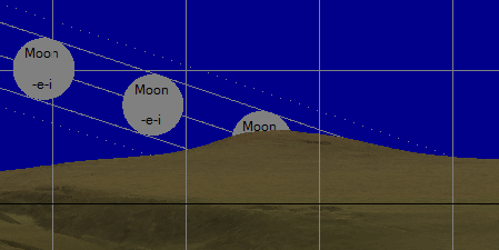
Thirteen Stone Hill Using LIDAR data
Moon Set over Hog Lowe Pike from Thirteen Stones Hill rendered from SRTM and OS Map Data.
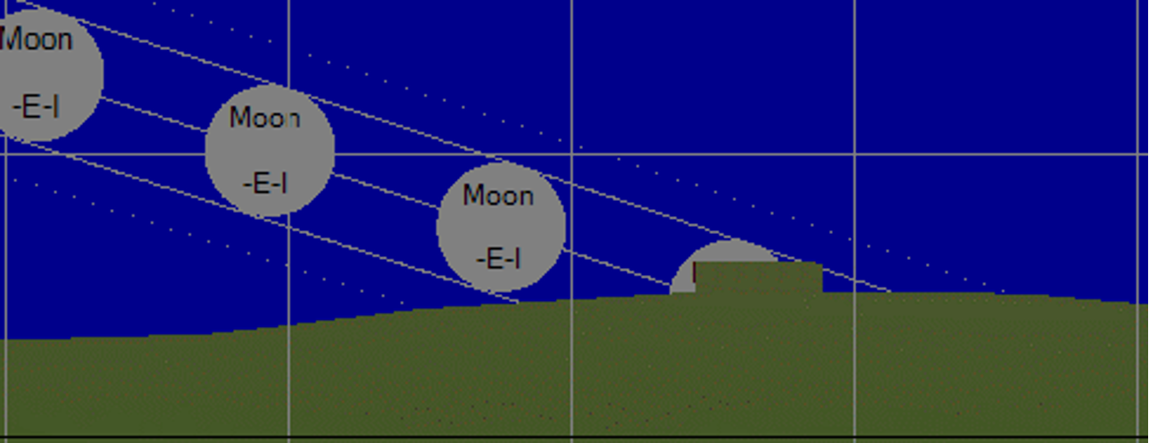
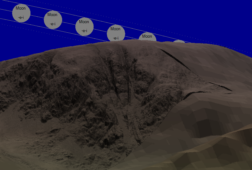
UK LIDAR data coverage for England and Wales is now generally good although not complete - most sites in England and Wales are rendered with LIDAR data and with missing areas filled with SRTM data. Where areas are infilled with SRTM data sometimes noticeable artefacts (they appear as discontinuities or even tears across the landscape) can often be seen although overall the quality and detail obtained from the use of LIDAR data is felt generally worthwhile.
Detail of Moon Set over Harter Fell showings LIDAR coverages (on the left) and infilled SRTM areas on the right.
GPX Data
The Viewer also contains links to GPX files for each location. These files allow you to see where on a map the various rising and setting points of the Sun and Moon are. This allows you to pinpoint a foresight such as mountain or hill where the event occurred.On Windows 10, you can install a GPX viewer with the following link. Other web based viewers are available such as Ride With GPS.
Using the Viewer
The viewer can take several parameters including the following
name=string - this is a case insenstive search string
country=Country Code (IM GG JE IE FR BE CZ PL DE GR PT NO SE CH ES MT IT DK NL UK XX)
area=County - the area of the country
type=All|Stone Circle|Standing Stones|Standing Stone (Menhir)|Stone Row - Alignment|Henge
grid=None|grid|fgrid - Specify whether to include a grid (1 degree intervals) or a fine grid (10 minute intervals).
res=High|Med|Low - Specify the image resolution (120, 60 or 30 pixels per degree).
label=None|labels - Display spot heights from OS Maps if available.
year=3700|4000|4500|5000 - Select the year - either 1750BC (3750), 2000BC (4000), 2500BC, (4500) or 3000BC (5000).
zoom=5|10|15|20|30|40|60|80|100|120|140|180 - Specify the Zoom Level.
x=0|360 - Specify the image X position in Degrees from 0 (North) to 360.
y=-1|20 - Specify the image Y position in Degrees from horizon (-1 to 20).
A type URL would be something like the following
http://www.standingstones.org/viewer.html? grid=grid&res=High&label=labels& year=5000&area=Gwynedd
Mathematics
Elevation and Azimuth of the Sun/Moon
The formula for calculating the Elevation and Azimuth of the Sun/Moon can be found at the following:https://astronomy.stackexchange.com/ questions/1855/how-to-get-the-longitude-latitude-from-solar-zenith-azimuth
In order to calcualte the size of the sun and moon when drawing, it is assumed that all orbits are circular.
Equinox positions are calculated at the true equinox and not at half the number of days between solstices. The different between the two approaches means that the ancient equinox positions may well have been somewhat different to the true equinox position. Similarly, the Cross Quarters are calculated based on the astronomical value which may vary slighlty from the ancient values used.
Adjusting for Parallelax
Parallelax for both the sun and moon is calculated although only the values for the moon are significant. Only the mean parallex of the moon is used which at the horizon is about 57′. The Parallelax variation due to the moon's eliptical orbit can vary by around +-3′ but this is not currently displayedhttps://en.wikipedia.org/wiki/ Orbit_of_the_Moon
Adjusting for Refraction
The formula for Refraction is the following Sæmundsson equation, taken from the wikipedia page which is accurate to around 0.1′ at 10 °C https://en.wikipedia.org/wiki/ Atmospheric_refraction
Adjusting for Moon "Wobble"
The moon has an additional wobble with a 173.3 day period of approximately +-9′ - this is displayed on either side of the moon as a series of dots.Drawing the Landscape
The main formulas used when calculating what to draw is the Aviation Formulary and Haversine formulasfrom: Ed Williams' Aviation Formulary
https://edwilliams.org/avform.htm
Haversine formula is used to Calculate distance (in m) between two points specified by latitude/longitude (in numeric degrees).
https://en.wikipedia.org/wiki/ Haversine_formula
Landscape dip and teresstial refraction
The dip is calculated simply based on distance and curvature of the earth and then adjusted following the R′ = R × 7/6 formula.
https://en.wikipedia.org/wiki/ International_Standard_Atmosphere
https://www.metabunk.org/standard-atmospheric-refraction-empirical-evidence-and-derivation.t8703/#post-205947
https://aty.sdsu.edu/explain/ atmos_refr/horizon.html
OS Grid Conversion
Conversion of spot heights and contours from the grid reference system (OSGB-36) to Lat/Long is using formulation implemented by Thomas, Redfearn, etc and is as published by OS.The following is a Javascript implementattion of the algorithm that was convered to C#.
wwww.movable-type.co.uk - Convert between Latitude/Longitude & OS National Grid References
Sun Moon Calculator
The following is a screen shot of the Sun and Moon calculator showing some of the maths for the Moel Y Llyn Stone Circle for the distant moon set. Probably not very pretty but very useful for working out bearings, distances, Grid Refs and generally checking results. It now calculates the rising and setting positions of the sun/moon assuming a rise or set over the sea.
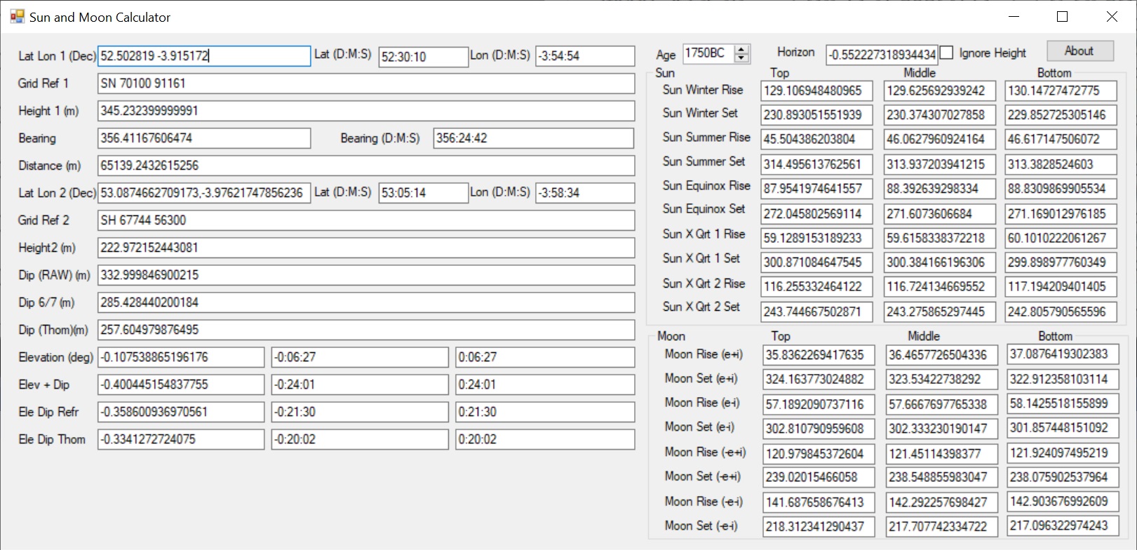
SunAndMoonCalculator.zip - ZIP of the calculator
In order for the calculator to access height data, this must be stored within a folder called "%appdata%\SRTM Data\". The SRTM tiles (e.g. N27W013.SRTMGL1.hgt.zip) can be downloaded from 30-Meter SRTM Tile Downloader
In additional, for those with Excel, there is a basic calculator written in XLSX EarthNumbers.xlsx - Simple Excel based calculator This calculator is based on the same maths as the rest of the site although the refraction calculations work are somewhat different.
Panorama Landscape Generator
The images on the Standing Stones web site are produced by a program called OpenPanorama which is now available to download from these links:
OpenPanorama.zip - ZIP of the newer open source OpenPanorama program.
linux-arm.zip - ZIP of the newer open source OpenPanorama program for Linux ARM.
linux-arm64.zip - ZIP of the newer open source OpenPanorama program for 64bit Linux ARM.
linux-x64.zip - ZIP of the newer open source OpenPanorama program for 64bit Linux X64.
runtimes.zip - Linux runtimes.
Panorama.zip - ZIP of the Windows only program..
OpenPanorama Source - Github link under GNU Affero General Public License v3.0
This program is still a work in progress so there are some rough edges.
Panorama is able to use SRTM, OS 50m data and LIDAR data to draw landscapes. Now supports wireframe output.
Multiple command lines options are available:-
-drawJobs (draw cairns, stones etc). Attempts to draw circles, stones and cairns when bulk processing from a list of CSV files.
-PosRange <angle> - Draw degrees above horizon. The default is 20 degrees above horizontal.
-NegRange <angle> - Draw degrees below horizon. The default is 5 degrees below horizontal.
-lidar (Process LIDAR data for locations).
-lidarfolder (Location where the LIDAR source data is stored (ZIPs and ASC files))
-lidarcache (Location to save processed binary LIDAR cache data for later use)
-lidarrange MaxDistance (Maximum distance (m) from observer to use LIDAR data - default 10000m)
-f OutputFilename
-r (replace file if it already exists)
-country <xx> - short country code, e.g. FR for France – uses ISO country codes apart from UK for GB
-CountryLong <country> - long country name, e.g. France
-match <sitename> - only processes bulk sites form CSV that match the name.
-region <region> - Region Filter - only process sites from CSV that match region
-hf <height> - Height Filter – only process sites from CSV above height.
-county <CountyFile> - Region of the site
-countyHTML <CountyFileHTML> - obsolete - not generally used anymore.
-locs (dump location GPX files when bulk processing from a list of CSV files. The GPX files are used to display maps of specific countries/regions)
-mr - Create multiple resolutions of images (30, 60 pixels per degree). 30, 60 pixels per degree). Create images at the specific Pixels Per Degree value (default 120) and half resolution (60) and quarter resolution (30).
-ch - Save Horizon GPX File. This allows a map to be displayed of the horizon as seen from a site.
-pp - Create Passing Points GPX File, where the sun/moon cross the horizon. These GPX files allow a map to be displayed showing the sun and moon rising and setting positions for a site.
-labels (Add OS spot height labels - The OS Map data has spot heights that by default are not drawn. This adds these in with Latitude and Longitude.)
-spots (Add OS spot markers when processing CSV Bulk Data - The OS Map data has spot heights that by default are not drawn. This adds these in with Latitude and Longitude.)
-nospots (Don't add OS spot markers)
-contours (Add OS Contours)
-srtm (Use SRTM Data)
-grid (add a grid)
-fgrid (fine grid)
-allgrids (Create files with no grid, grid and fine grid in one go)
-stellarium (Generate Stellarium ZIP file)
-out OutputFolder
-srtmFolder <folder> - SRTM Source folder name, e.g. %USERPROFILE%\Appdata\roaming\SRTM Data
-osFolder <folder> - OS Maps 50M data FOlder e.g. %USERPROFILE%\Appdata\roaming\OS Terrain 50
-p Pixels (pixels per degree - default 120)
-oldcsv <oldcsvfile> - Not really used any more
-json JSONOutFile (Create JSON File)
-max MaxDistance in M
-l Location
-a age
-t (Create Template file)
-tf InputTemplateFilename
-d Description
-h Height
-csv CSVFiles (Bulk process from a list of CSV files)
-threads N (Number of threads to run)
-Solstice - Draw Sun Solstices
-Equinox - Draw Sun Equinox
-xq - Draw Sun Cross Quarters
-Moon+e+i - Draw Moon +e+i
-Moon+e-i - Draw Moon +e-i
-Moon-e+i - Draw Moon -e+i
-Moon-e-i - Draw Moon -e-i
-AllSun - Draw all Sun positions
-AllMoon - Draw all Moon positions
-CacheLIDAR N (Number of LIDAR tiles to cache (400MB per tile, default 4)
-CacheSRTM N (Number of SRTM tiles to cache (26MB per tile, default 12)
-CacheOSMap N (Number of OS Map tiles to cache (few MB each, default 150)
-ColourSea <RGB> - Default is Hex RGB (e.g. 000000) for Black
-ColourSky <RGB> - Default is Hex RGB for Blue
-ColourBase <RGB> - Default is Hex RGB for DarkGreen
-ColourTops <RGB> - Default is Hex RGB for Brown
-ColourDistant <RGB> - Default is Hex RGB for DimGray
-ColourOriginLatitude <latitude> - default 45
-ColourSlopeAdjust <int> - default 20
-ColourMaxDist <metres> - default 10k
-ColourGreenBrownShades <count) - default 40
-ColourGreyCount <count) - default 80
-ColourMaxHeight <height> - max height colour in metres
-ColourMoon <RGB> - Default is Hex RGB for Grey
-ColourSun <RGB> - Default is Hex RGB for Yellow
-ColourSaMText <RGB> - Sun and Moon Text - Default is Hex RGB for Black
-ColourTitle <RGB> - Default is Hex RGB for White
-ColourCairns <RGB> - Default is Hex RGB for Red
-ColourStones <RGB> - Default is Hex RGB for DarkGrey
-ColourSpotHeight <RGB> - Default is Hex RGB for Dark Red
-ColourReticleBackground <RGB> - Default is Hex RGB for White
-ColourReticleMajor <RGB> - Default is Hex RGB for Dark Grey
-ColourReticleMinor <RGB> - Default is Hex RGB for Grey
-ColourReticleHorizontal <RGB> - Default is Hex RGB for Black
-ColourReticleText <RGB> - Default is Hex RGB for Black
-CopyrightNotice <Text> - Change Copyright Notice Text
-DumpHeights <string> - Where string is latitue, longitude, lat Increment, lon Increment, lat Count, lon count (e.g. "53.068053, -4.076761,2.777777777777778e-5,2.777777777777778e-5,100,100")
-MaxJobs <number> - Stop processesing after at most N jobs (the MSFT ZIP library leaks badly so useful to restart after N jobs - for LIDAR sites set N to ~3)
-ProximalInterpolation - Perform Proximal Interpolation rather than Linear (Mincraft mode)
-ObserverHeight <height> - Observer eye height (1.5m)
-SiteTypes = <types> - where default types are "Stone Circle,Ring Cairn,Standing Stone(Menhir),Standing Stones,Stone Row / Alignment,Henge,Multiple Stone Rows / Avenue,Timber Circle,Viewpoint"
-BlobStoreURL <URL> - where URL default is storageURL + ""
-ViewGPSURL <URL> - where URL default is "https://gpsvisualizer.com/atlas/map?url="
-ViewImageURL <URL> - where URL default is "http://www.standingstones.org/viewer.html?name="
-MegpURL <URL> - where URL default is "https://www.megalithic.co.uk/article.php?sid="
-StandStonesHost <URL> - where host default is www.standingstones.org
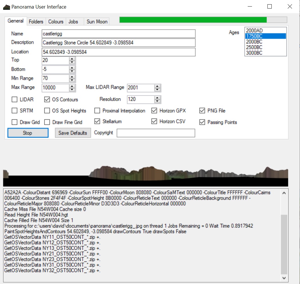
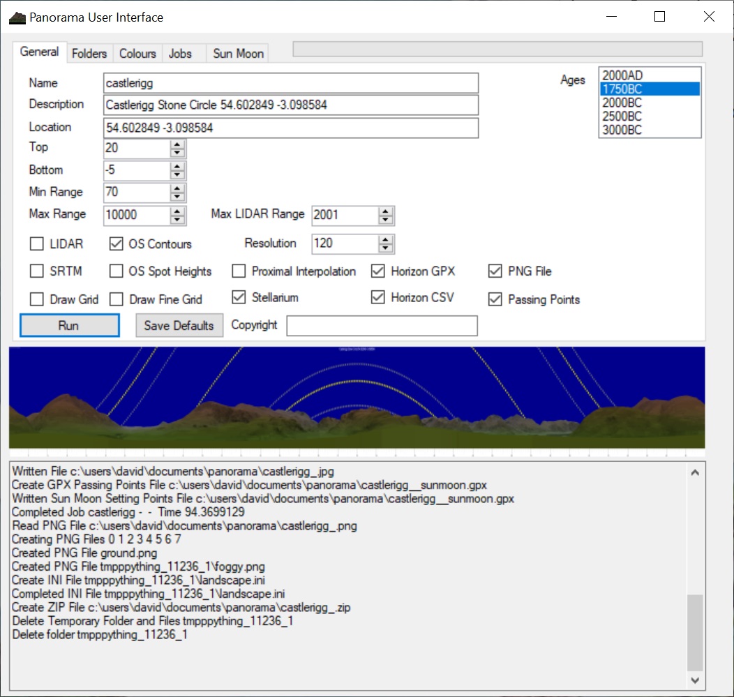
The following is a screen shot of the Panorama UI program showing a couple of example renders of Castlerigg, one part way through and the other after completion. A hopefully useful front end to the command line panorama program.
Stellarium
Stellarium is a free open source planetarium for your computer. It shows a realistic sky in 3D as you would see with the naked eye, binoculars or a telescope.
http://stellarium.org/
Each site in the Viewer has a Stellarium ZIP file link - this link allows you to download the landscape in a format suitable for input into Stellarium. Within Stellarium, hit F4 and then select import landscape to play.
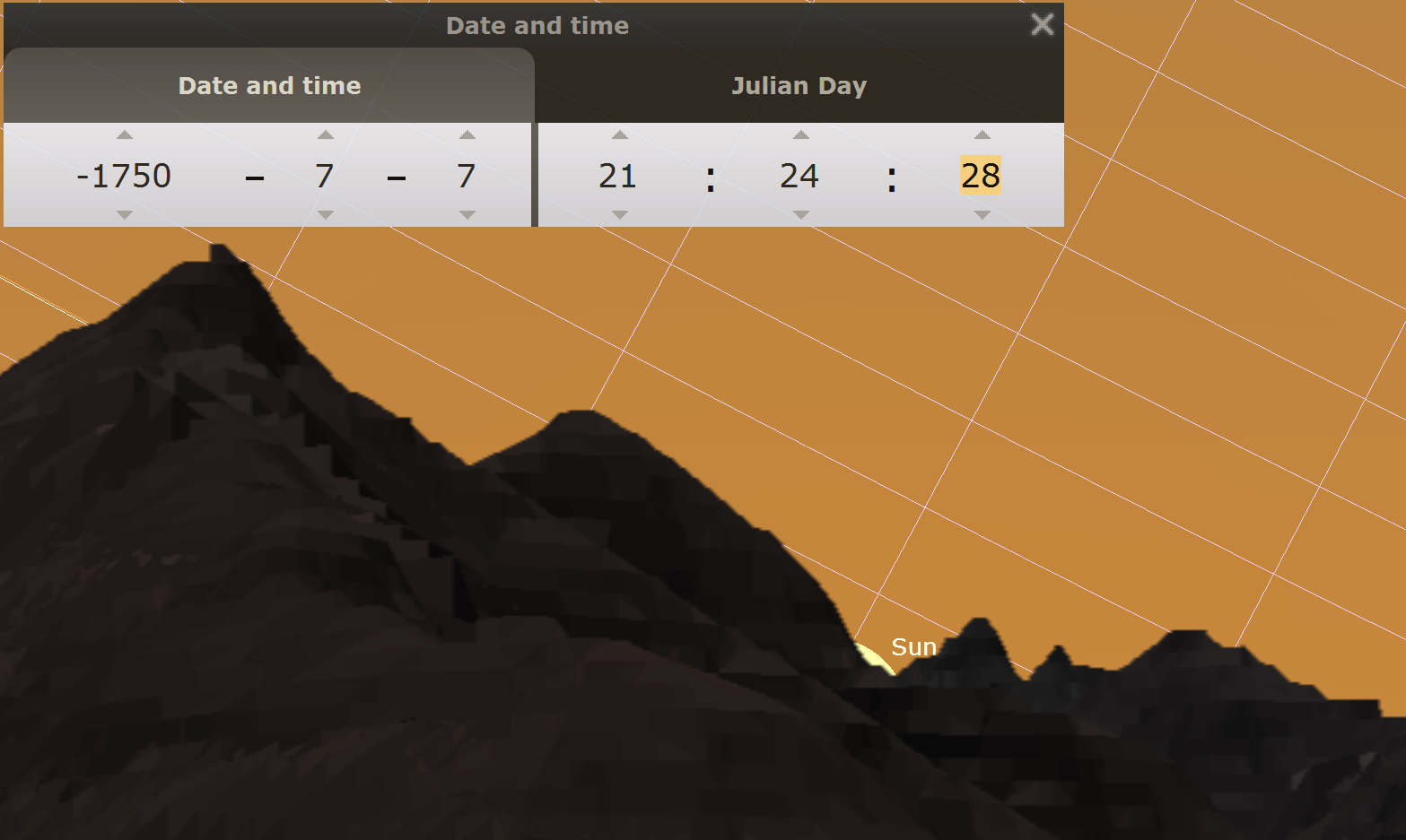
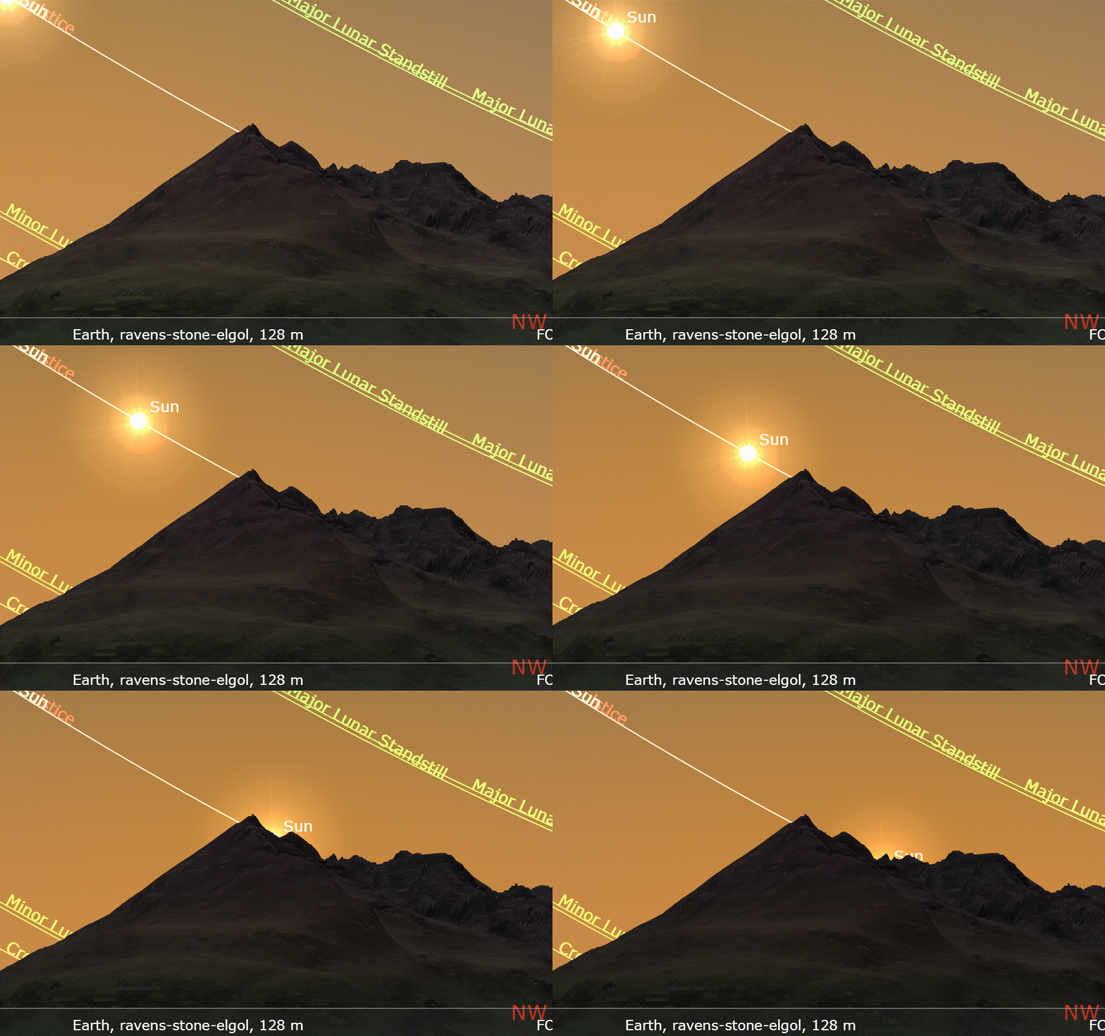
The following is an example image from Stellarium of the Mid Summer Sunset from Raven's Stone, Elgol on Skye and shows the initial sunset followed by two detailed views as the sun peeks out over the next 15 minutes after initially setting:
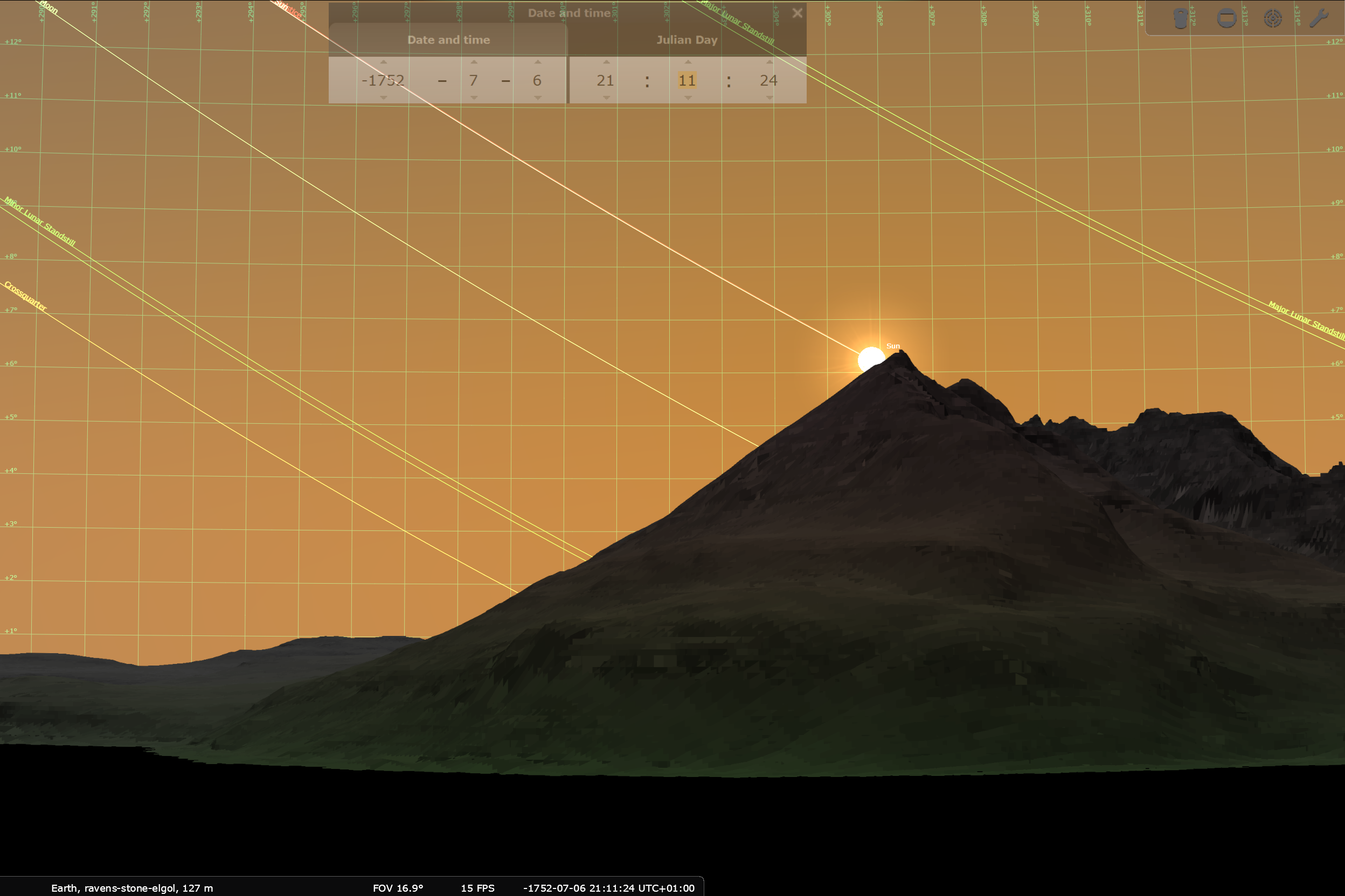
The sun sets, then peeks out twice as shown below before finally setting:
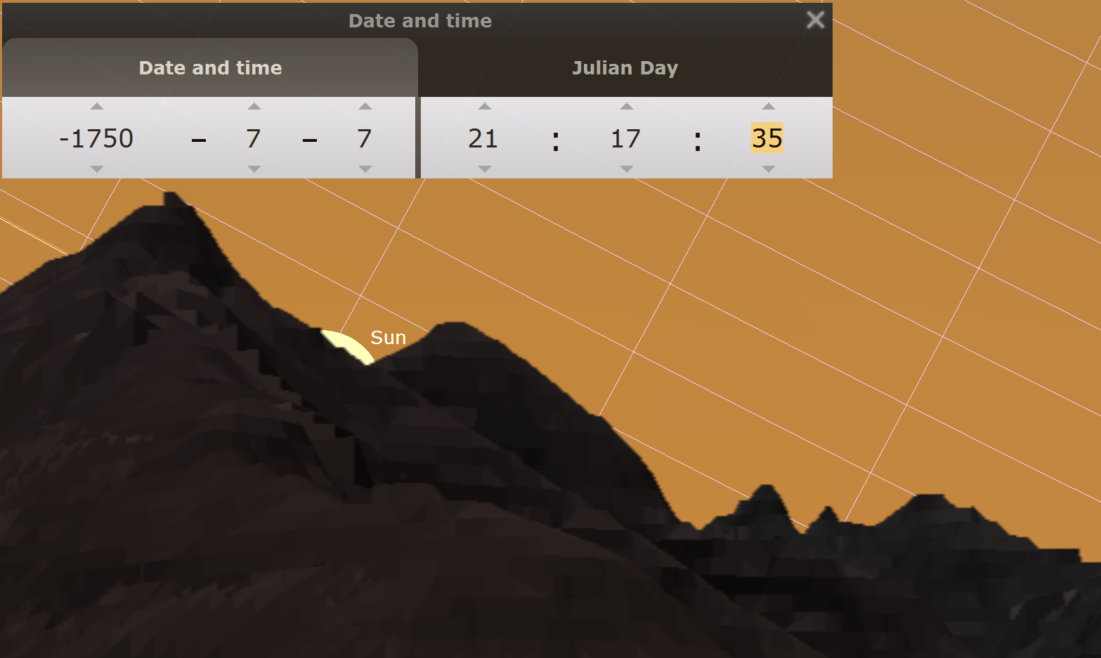
For comparison with the viewer, select the following link -
Detail of the Elgol sunset in the StandingStones.org viewer
A brief walkthrough of setting up Stellarium to look at sites
Using Stellarium to view www.StandingStones.org Sites.pdf
High Resolution (180points/degree) Stellarium file for Mitchells Fold
mitchells-fold_so30429837_.zip
Stellarium Animations
Sample Stellarium Animations for various UK sites. Stellarium has a very powerful programming environment that allows locations to be selected, dates and times set and images to be captured. Stellarium scripts are written in JavaScript and hence quite powerful programs can be written and run. The following animations were generated by creating a series of images and then converting them into animated GIFs. A single example is below but additional images can be found at the following link - a drop down on this page allows different counties to be selected. A selection of sites across multiple counties was used that show interesting rises and sets.Stellarium Animations
Stellarium Animations aberdeenshire
Stellarium Animations anglesey
Stellarium Animations argyll
Stellarium Animations highlands
Stellarium Animations ceredigion
Stellarium Animations cheshire
Stellarium Animations cumbria
Stellarium Animations derbyshire
Stellarium Animations dorset
Stellarium Animations gwynedd
Stellarium Animations hampshire
Stellarium Animations herefordshire
Stellarium Animations isle-of-harris
Stellarium Animations isle-of-lewis
Stellarium Animations isle-of-mull
Stellarium Animations isle-of-skye
Stellarium Animations lancashire
Stellarium Animations pembrokeshire
Stellarium Animations perth-and-kinross
Stellarium Animations powys
Stellarium Animations wiltshire
Source code is linked below - Stellarium creates a series of images that are converted in GIFf using the following
ffmpeg.exe -f image2 -framerate 10 -i "filename_%03d.png" "filename.gif" -y
Stellarium Animations Source - StellariumAnimation.ssc
Background and Papers by J R Hoyle (my father)
Upheavals in the third millennium BC
A discussion of the upheavals that happened in the third millennium BC. Earlier rings tend to be
larger than more recent rings and also appear to use a different unit of length, coined the
“Old Yard” by my father rather than Thom’s more recent “Megalithic Yard”. The change from
using the Old Yard to the Megalithic Yard may correlate with the influx of the Beaker people
into the UK who largely replaced the former inhabitants of the UK. In genetic terms, the takeover
was greater than 90% so this would have been a massive change with the former people replaced
through some combination of war, disease or other disaster. After the Beaker people took over,
most circles and monuments seem to have been build to more modest sizes than previously although
with Stonehenge proving the exception to the rule. It is suggested that Stonehenge was built
possibly to celebrate the victory of these folk and would be seen as a direct replacement of
the now abandoned nearby site of Avebury.
Upheavals in the third millennium BC 2.pdf
Possible Site of the Original Bluestone Ring - paper by my father by John R. Hoyle
bluestones for net publication 7.pdf
Megalithic Astronomy or Megalithic Moonshine?
An astroarchaeological investigation of a number of prehistoric sites within about ten miles of the mountain Cadair Idris in South Gwynedd
and North Powys looking at the sun and moon rising and setting positions on the horizon.
Megalithic Astronomy or Megalithic Monshine.pdf
Surveys of Moel y Llyn and Lle’r Neuaddau
Chapter 2 Recent surveys.pdf
Chapter 2 Recent Surveys For MPP.pdfOlder version of the paper with a few errors but that includes some of the survey raw data
Prehistoric Pennal - A talk by J. R. Hoyle
Prehistoric Pennal.pdf
An illustrated talk on Welsh Stone Rings By John R. Hoyle and Robert Price
Originally presented at the Tabernacle, Machynlleth, Powys, Wales.
Tabernacle Welsh rings.pdf
Units of length - a Study of different units of length by J R Hoyle
Units of length 2.pdf
Persistence in the use of Units by J R Hoyle
A brief investigation of some evidence for the persistent use of the Megalithic Yard Unit into later time periods
Persistance in the use of units.pdf
Possible Origin of the Megalithic Yard - a theory for the origin by J R Hoyle
The origin of the Megalithic Yard is obscure and numerous attempts have been made to link it to
other units in use in the old world, but none has been convincing. To these I will add another
suggestion - the suggestion is that people started producing bows and arrows on an industrial
scale and produced them to exacting standards. The standard arrow could have become the standard
measurement unit and would automatically be carried wherever their warriors went. This then
could be the length that Thom discovered, which he called the Megalithic Yard.
Possible Origin of the Megalithic Yard.pdf
The Thirteen Stones Hill Ring - A Reassessment by J R Hoyle
An examination of the site, the rising and setting points of the sun and moon and discussion about the destruction of the site.
The Thirteen Stones Hill Ring Reassessment 2.pdf
Summer Solstice Over Cadair Idris From Two Sites by J R Hoyle
A study of two stones aligned to view the summer solstice over Cadair Idris
Summer Solstice Over Cadair Idris From Two Sites.pdf
Other Stuff
A map of the North Preselis generated my "Stone Circle Detector" program that generates a map of where setting/rising of the sun/moon can be observed for various foresights.
preselinorth.gpx Map
A map of the Anglesay generated my "Stone Circle Detector" program that generates a map of where setting/rising of the sun/moon can be observed for various foresights.
angleseysunandmoon.gpx Map
As part of the work, a bulk process of all UK sites was performed to see if there are correlations between peaks and notches detected in landscapes and the rising and setting positions of the Sun and Moon. In addition, positions where the sun or moon skims the landscape and partially or fully disappears and then reappears were noted. These positions have been collected into a single spreadsheet which can be downloaded from the following link. These positions potentially could be useful to people wishing to do statistical or other analysis on UK sites for astroarchaeological purposes. All of these data in these files have been gathered using automated processes and no manual intervention. Happy to discuss details of the algorithms used if anyone fancies looking at the data to see if there are any statistically significant results within. Ages calculated in the data include 2000AD (0), 1750BC (3750), 2000BC (4000), 2500BC (4500) and 3000BC (5000). The data includes Sun rising and setting correlation positions for Solstices, Equinoxes and Cross Quarters. Moon rising and setting positions include major and minor positions (+e+i, +e-i, -e+i and -e-i).
RisingandSettingSkimmingsAndCorrelations.xlsxAllSkims.csv
AllPeaks.csv
Alldeclpeaks.csv
AllCorrelations.csv
Sometimes the LIDAR and OS Map data heights diverge from each other and where this happens, the rendering can be somewhat off. The LIDAR Check Link below page shows locations where there are OS Map points (either spot heighs or contours) with heights that are 4m or more different than the LIDAR data.
This often occurs when the location is in woodland, at the edge of the sea, in quarries or locations where building work has occurred. Luckily instances where the values for hilltops being significantly out is quite rare.
An example of this is for the Nipstone (52.566630, -2.950539) which seems to have been largely removed by the LIDAR processing - SO39 Map that covers the Nipstone
About and Copyright
Copyright David Hoyle 2021.
The Standing Stone shown twice on the home page is Esguan Stone near Tywyn, Gwynedd, Wales
Cookies and privacy - I prefer to call them biscuits but I'm from the UK. At present we don't use cookies on www.StandingStones.org. https://en.wikipedia.org/wiki/Cookie
Maps images by Captain Blood - Own work, CC BY-SA 3.0, https://commons.wikimedia.org/w/index.php?curid=930331
By Maximilian Dörrbecker (Chumwa) - Self made, using Northern Ireland - Counties copy|this map by NNW, CC BY-SA 2.5, https://commons.wikimedia.org/w/index.php?curid=7918534
This Serbia map file is licensed under the Creative Commons Attribution-Share Alike 3.0 Unported license. https://creativecommons.org/licenses/by-sa/3.0/legalcode
The Turkey map is by Atilim Gunes Baydin - Self drawn from scratch, based on data from official Turkish motorway network map, CC BY-SA 3.0, https://commons.wikimedia.org/w/index.php?curid=1482439
Map of Slovakia - Matissek, CC BY-SA 3.0 https://creativecommons.org/licenses/by-sa/3.0, via Wikimedia Commons
Slovenia - TUBS, CC BY-SA 3.0 https://creativecommons.org/licenses/by-sa/3.0, via Wikimedia Commons
Bulgaria map - By Tourbillon - Own work, CC0, https://commons.wikimedia.org/w/index.php?curid=17072829
Cyprus - By Ufo karadagli - Own work, CC BY 3.0, https://commons.wikimedia.org/w/index.php?curid=14741424
Estonia - By Staberinde - based on by NordNordWest, CC BY-SA 3.0, https://commons.wikimedia.org/w/index.php?curid=86092060
Luxembourg - Public Domain, https://commons.wikimedia.org/w/index.php?curid=31862
Latvia - Lasks, CC BY-SA 4.0 https://creativecommons.org/licenses/by-sa/4.0, via Wikimedia Commons
Moldova - By Andrein - File:Moldova_administrative_map.png, CC BY-SA 3.0, https://commons.wikimedia.org/w/index.php?curid=20514536
Romania - By Andrein - Own work, CC BY-SA 3.0, https://commons.wikimedia.org/w/index.php?curid=5026940
San_Marino - By Aotearoa - Own work, CC BY-SA 3.0, https://commons.wikimedia.org/w/index.php?curid=776508
Syria - By TUBS - Own work This W3C-unspecified vector image was created with Adobe Illustrator. This file was uploaded with Commonist. This vector image includes elements that have been taken or adapted from this file: Hama in Syria (+Golan hatched).svg (by TUBS)., CC BY-SA 3.0, https://commons.wikimedia.org/w/index.php?curid=20604743
bottomImageName